202
202
Oct 27, 2012
10/12
by
WRC
tv
eye 202
favorite 0
quote 0
a lot of people haunted by last year's hurricane irene, see what they are doing to prepare. >> also, pictures >> hurricane sandy expected to come ashore on monday and people across the north east are making plans to try to get out of harm's way. hurricane sandy is blamed for at least 40 deaths in the caribbean. >> it is now turning towards the u.s. bringing heavy rains, high wind and flooding to much of eastern seaboard. daniel lee has the latest now from chesapeake beach, maryland. >> hurricane sandy poundedity way through the caribbean today, ripping homes apart and leaving streets under water. at least 40 people died in haiti, cube why and jamaica. as sandy moves up the coast, setting to clobber the northeast, people are preparing for the worst. >> we just have to do it, m mill ford beach connecticut, boarding up his brand new home. last year's hurricane irene forcing him to rebuild, now he is hoping sandy won't do the same. >> you know, you have to prepare. >> from virginia to new england, several governors declaring emergencies and issuing warnings. >> assume there is an elongat
a lot of people haunted by last year's hurricane irene, see what they are doing to prepare. >> also, pictures >> hurricane sandy expected to come ashore on monday and people across the north east are making plans to try to get out of harm's way. hurricane sandy is blamed for at least 40 deaths in the caribbean. >> it is now turning towards the u.s. bringing heavy rains, high wind and flooding to much of eastern seaboard. daniel lee has the latest now from chesapeake beach,...
45
45
Oct 28, 2012
10/12
by
MSNBCW
tv
eye 45
favorite 0
quote 0
a lot of people feel that i got through irene, i can get through this. this is a different type of storm. first of all, it's going to cause greater flooding in areas that were not flooded during irene. the wind in areas that were not hit by irene with wind problems, those areas -- people really need to take seriously and be prepared. it's almost getting to the point where it's too late because finding food, finding water, finding flashlights and generators is becoming impossible now. >> sir, good advice. hopefully people are getting good advice. jerome hauer, we'll let you get back to work. we appreciate you taking time out of our schedule. this is msnbc's extended coverage of this october surprise, hurricane sandy looming over a huge area of the eastern u.s., threatening to disrupt things for tens of millions of people, over nearly a quarter of the lower 48 states. we're back after this. when a twinge of back pain surprises him. morning starts in high spirits, but there's a growing pain in his lower back. as lines grow longer, his pain continues to ling
a lot of people feel that i got through irene, i can get through this. this is a different type of storm. first of all, it's going to cause greater flooding in areas that were not flooded during irene. the wind in areas that were not hit by irene with wind problems, those areas -- people really need to take seriously and be prepared. it's almost getting to the point where it's too late because finding food, finding water, finding flashlights and generators is becoming impossible now. >>...
125
125
Oct 26, 2012
10/12
by
WMAR
tv
eye 125
favorite 0
quote 0
. >> reporter: of course you remember the frustration surrounding irene, the executive addressed that today, he has received ainsurances that the -- assurances from bge that they will receive notices. the county has to bring in the crews to cut down the trees to get the limbs out of the way before the crews can come in to fix the lines. this time around, they should be better prepared as well. reporting live in baltimore town can county, jeff hager, abc2 news. >> if you are a boater, you are always keeping an eye on the weather. crews are getting the harbor ready to ride out the storm. >> reporter: when a town is centered around the city dock, the problems that storms bring are nothing new. >> we are preparing for the worst as we always do, and hoping for the best. the harbor master for annapolis. the rain is is not is what concerns him the most, it's the wind. >> coastal flooding, that is driven by southeasterly winds preventing the bay from draining. we are traveling down, heading south for the winter, spend time in the bahamas. >> reporter: that was the plan for ray and his friends
. >> reporter: of course you remember the frustration surrounding irene, the executive addressed that today, he has received ainsurances that the -- assurances from bge that they will receive notices. the county has to bring in the crews to cut down the trees to get the limbs out of the way before the crews can come in to fix the lines. this time around, they should be better prepared as well. reporting live in baltimore town can county, jeff hager, abc2 news. >> if you are a...
777
777
Oct 27, 2012
10/12
by
WMAR
tv
eye 777
favorite 0
quote 0
damage from irene topped $14 billion. and sandy could wreak even more havoc. >> certainly having lived through it. i lost everything in my basement. i had up to ten feet of water in my house. this is a concern. >> reporter: governor cuomo has declared a state of emergency in preparation for sandy's impact. and mayor michael bloomberg warned new york city residents to brace themselves. >> there's the possibility of parts of our city flooding or high winds that could force certain bridges to be closed. >> reporter: last year, in advance of irene, mayor bloomberg made the unprecedented order to evacuate low-lying areas of the city and shut down the subway system. as sandy barrels north, the city's more than 7 million strap hangers await a decision about another possible shutdown. and mayor bloomberg says the subway system will shut down if the wind speeds exceed 39 miles per hour. now, he also recommends that residents put together a go pack with all of the essentials, should you need to evacuate at a moment's notice. >> pot
damage from irene topped $14 billion. and sandy could wreak even more havoc. >> certainly having lived through it. i lost everything in my basement. i had up to ten feet of water in my house. this is a concern. >> reporter: governor cuomo has declared a state of emergency in preparation for sandy's impact. and mayor michael bloomberg warned new york city residents to brace themselves. >> there's the possibility of parts of our city flooding or high winds that could force...
1,045
1.0K
Oct 29, 2012
10/12
by
WJLA
tv
eye 1,045
favorite 0
quote 0
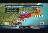
the last time was hurricane irene, that was august of last year. this resident lives right on the beach. he, of course, is worried about the waves. >> i'm really, really worried because they just told a friend of mine they think it is going to hit the bay. bay and ocean is going to come together. >> the storm surge along some areas of the east is expected to be 11 feet or higher. and just made worse by the full moon. >> absolutely. hurricane sandy at this hour is still hundreds of miles offshore. but even from that distance, she has battered the coast of north carolina. fierce, unrelenting winds blew off the water all day sunday. the rain that came with it flooded towns inland from the shore. now a cold front is moving in from the west. that is a chilly and unusual aftereffect for a hurricane. people in the carolinas and along much of the east coast scrambled to secure their boats. sandy's outer bands washed away this 30-foot boat and several others along north carolina's crystal coast. some boats were pushed on shore and a mobile home park ended u
the last time was hurricane irene, that was august of last year. this resident lives right on the beach. he, of course, is worried about the waves. >> i'm really, really worried because they just told a friend of mine they think it is going to hit the bay. bay and ocean is going to come together. >> the storm surge along some areas of the east is expected to be 11 feet or higher. and just made worse by the full moon. >> absolutely. hurricane sandy at this hour is still...
106
106
Oct 29, 2012
10/12
by
CNNW
tv
eye 106
favorite 0
quote 0
looks like it will be higher than irene. that has folks worried in new york harbor and here in new jersey. here's what governor chris christie had to say about his warning to the state yesterday. >>. >> so, don't be stupid, get out and go to higher ground. the margin for me being wrong and you staying at a friend's house is significantly better than winding up with severe energy or death for yourself or for your family. >> some public officials caught heat after hurricane irene. some felt it was overblown. i stand by warnings because it's better to be safe than sorry. this is bigger and in many instances badder than hurricane irene was over 12 months ago. back to you. >> thank you. chris christie is completely right. just go to higher ground just for a couple of days. bring some stuff. if you're wrong, fine. this is not shaping up to be something anything like irene. new york city we're bracing for the impact. mass transit was shut down last night. buses, rail system were brought to a halt. 7 p.m. is when they stopped last n
looks like it will be higher than irene. that has folks worried in new york harbor and here in new jersey. here's what governor chris christie had to say about his warning to the state yesterday. >>. >> so, don't be stupid, get out and go to higher ground. the margin for me being wrong and you staying at a friend's house is significantly better than winding up with severe energy or death for yourself or for your family. >> some public officials caught heat after hurricane...
232
232
Oct 28, 2012
10/12
by
MSNBCW
tv
eye 232
favorite 0
quote 0
we lucked out with irene, and i don't know. this may be worse. >> nbc's tom strong traung is l rehoboth beach, delaware. any residents left? >> they have about eight hours, the governor issues a mandatory evacuation area. everybody must be out by 8:00. look down the beach, have you several dozen people trying to get their last glimpse. right now, low tide. looks pretty impressive. come high tide, around 6:30, it wouldn't be a surprise if we didn't see water coming up to this fence here. all around rehoboth beach, a lot of businesses boarded up. people making runs to the grocery store, water short, bread is short. people did what they could in terms of preparation. they had about eight hours, around that time, this area will be shut down. cut off the bridges and roads into here it won't be a very pleasant place to stay if the electricity is going to go out. which is a likelihood. 2,000 utility workers and we're talking about the maryland/dc area, baltimore areas, and states of emergencies in those areas as well. a lot of people
we lucked out with irene, and i don't know. this may be worse. >> nbc's tom strong traung is l rehoboth beach, delaware. any residents left? >> they have about eight hours, the governor issues a mandatory evacuation area. everybody must be out by 8:00. look down the beach, have you several dozen people trying to get their last glimpse. right now, low tide. looks pretty impressive. come high tide, around 6:30, it wouldn't be a surprise if we didn't see water coming up to this fence...
144
144
Oct 27, 2012
10/12
by
CNN
tv
eye 144
favorite 0
quote 0
. >> you know, irene was more of a direct hit in a way because this area saw a lot of flooding, saw a lot of rain from it. in fact, i was speaking with someone here just a few minutes ago about what happened in this area, this highway 12. coastal highway 12. there was a major section of that that washed away from the storm. this morning what we're expecting to see, again, that first band of strong winds, the rain that will be coming through, again, the storm has been downgraded, but officials are saying, you know, do not take the storm for granted. it still will be a strong storm that bring winds and anywhere from 40 to 50 miles per hour i was told. but, you know, at this point, people are paying very close attention, i should say, to what's happening out here in the skies. >> as they should. george howell in the outer banks of north carolina, thank you. >>> meanwhile, you know, millions of people could lose power from this storm and the edison electric institute is warning people that outages could last for seven to ten days. right now the area's most vulnerable to power outages are
. >> you know, irene was more of a direct hit in a way because this area saw a lot of flooding, saw a lot of rain from it. in fact, i was speaking with someone here just a few minutes ago about what happened in this area, this highway 12. coastal highway 12. there was a major section of that that washed away from the storm. this morning what we're expecting to see, again, that first band of strong winds, the rain that will be coming through, again, the storm has been downgraded, but...
131
131
Oct 27, 2012
10/12
by
CNNW
tv
eye 131
favorite 0
quote 0
it didn't generate a lot like irene didn't generate. so if this thing stays kind of like the irene, this becomes not a big deal. but that's not the forecast. not a single model does that. every model turns it back into the northeast, either from new york city all the way down to north carolina and then here's the rub that we've never gone through this before. there's not been ever an instance where a computer model has had to work this out in its head or in its computer. there's a cold air mass back here, there's a low here, and another low here, and they're going to combine. what is going to happen when those two combine, we honestly simply don't know. there's not been any history for this in the computer program. the program's only been running for 25 years. maybe a little bit less. >> so just explain to me briefly, what is so unique about that, that combination? >> you have the moisture from a tropical storm and then you have the wind and the energy and even the potential for snow with a low pressure that is a normal low pressure. it
it didn't generate a lot like irene didn't generate. so if this thing stays kind of like the irene, this becomes not a big deal. but that's not the forecast. not a single model does that. every model turns it back into the northeast, either from new york city all the way down to north carolina and then here's the rub that we've never gone through this before. there's not been ever an instance where a computer model has had to work this out in its head or in its computer. there's a cold air mass...
196
196
Oct 30, 2012
10/12
by
KGO
tv
eye 196
favorite 0
quote 0
. >> before this made landfall, this storm seemingly crushed irene. there really is no comparison, right? >> there's no comparison. i guess you could say, this is kind of like new york city's katrina. just devastating impacts here. this historic surge, 13 feet, all that water coming on in and the high wind gusts. worst-case scenario did pan out here unfortunately. >> all right. mark mann cue sew from accuweather. the airlines trying to get back to normalcy and what the red cau cross is doing to help out. >> plus more incredible rescues that didn't have to happen. we'll be right back. en. we'll be right back. >> announcer: "america this morning" brought to you by 5 hour energy. 5-hour energy supports the avon foundation for women breast cancer crusade. so i can get the energized feeling i need and support a great cause? i'm sold. pink lemonade 5-hour energy? yeah and a portion of every sale goes to the avon foundation for women breast cancer crusade. i'm sold. new pink lemonade 5-hour energy. get the alert, energized feeling you need and support breast
. >> before this made landfall, this storm seemingly crushed irene. there really is no comparison, right? >> there's no comparison. i guess you could say, this is kind of like new york city's katrina. just devastating impacts here. this historic surge, 13 feet, all that water coming on in and the high wind gusts. worst-case scenario did pan out here unfortunately. >> all right. mark mann cue sew from accuweather. the airlines trying to get back to normalcy and what the red cau...
53
53
Oct 29, 2012
10/12
by
CNNW
tv
eye 53
favorite 0
quote 0
the last time you did this, was it irene? >> it was. it was tropical storm irene in august 2011 where we essentially successfully helped to get people to safety before the storm, and then shutdown the transportation network in an orderly manner to protect the employees and equipment. >> before that, do you remember a time that we did this? >> weather-related -- that is probably the last time in memory we can recall shutting down the system. >> go ahead, chad. >> i know from riding the subway that the whole system is a sieve, and water can come in anywhere, did you sandbag low-lying subway entrances to try to stop the water from coming in? >> yes, absolutely. we have done the sandbagging at various locations to take the steps to protect our infrastructure. now, anyone who travels new york on occasion sees razed subway grates where we have taken efforts to raze them above street levels to prevent the flood water from enters the system. >> thank you, kevin ortiz, from the mta, and great information and the best of luck to you, and we may b
the last time you did this, was it irene? >> it was. it was tropical storm irene in august 2011 where we essentially successfully helped to get people to safety before the storm, and then shutdown the transportation network in an orderly manner to protect the employees and equipment. >> before that, do you remember a time that we did this? >> weather-related -- that is probably the last time in memory we can recall shutting down the system. >> go ahead, chad. >> i...
86
86
Oct 30, 2012
10/12
by
CNBC
tv
eye 86
favorite 0
quote 0
what happens particularly with irene last year, a lot of retailers learned to cope with this a lot better. so a few years ago, they would have had trouble restocking the stores once the hurricane was over. i expect this time the likes of target, walmart, home depot have put plenty of planning in and they probably started stocking five, section days before the event so they probably will not have as much of a restocking issue. >> let's talk about the christmas season then. to what extent does the storm matter at all? now perhaps people have to spend their money for things they need because they were destroyed perhaps in the storm or whatever. so they might have less disposable income for christmas presents. does that matter at all? >> i do think again none of this is particularly positive, but i wouldn't overstate its impact either. because i think this is coming in a lull, it's during a weekday. halloween is a bit worry because it's been a wash skrout. so if you haven't sold through that stock, you've lost the opportunity. for the rest of them, i think so far if you think about it the u.s
what happens particularly with irene last year, a lot of retailers learned to cope with this a lot better. so a few years ago, they would have had trouble restocking the stores once the hurricane was over. i expect this time the likes of target, walmart, home depot have put plenty of planning in and they probably started stocking five, section days before the event so they probably will not have as much of a restocking issue. >> let's talk about the christmas season then. to what extent...
227
227
Oct 29, 2012
10/12
by
WTTG
tv
eye 227
favorite 0
quote 0
again, last year, hurricane irene, we did see a lot of that sea foam and some of the waves breaching. definitely seeing some good action here with the water itself coming over the wall at this point. again, 17th, 16th street along the boardwalk. making aussie little bit nervous here. we'll continue to watch that. the seawall erected over hurricane gloria in 1985 and has not been breached since then. there is also concern about the other side, the bayside of ocean city. so we'll continue to watch all of that and that is the latest here live. back to you. >> hurricane sandy definitely going to test that seawall throughout the next coming days. lauren, thank you so much. >> we'll be right back with more coverage of hurricane in just a moment. this was a booming place. and mitt romney and bain capital turned it in to a junk yard. i was suddenly, 60 years old. i had no health care. mainly i was thinking about my family. how am i going to take care of my family. he promised us the same things he's promising the united states. and he'll give you the same thing he gave us. nothing. anncr: pri
again, last year, hurricane irene, we did see a lot of that sea foam and some of the waves breaching. definitely seeing some good action here with the water itself coming over the wall at this point. again, 17th, 16th street along the boardwalk. making aussie little bit nervous here. we'll continue to watch that. the seawall erected over hurricane gloria in 1985 and has not been breached since then. there is also concern about the other side, the bayside of ocean city. so we'll continue to...
90
90
Oct 28, 2012
10/12
by
KNTV
tv
eye 90
favorite 0
quote 0
we were talking last year tropical storm irene you may recall wasn't really that devastating. this system is going to be about two to three times more powerful when it moves onshore. you can see estimated rainfall. anywhere from 7 to 13 inches of rain and that does not include the storm surge so we're talking about storm surge up to three to five feet. that's the whole ocean moving in. if you have been to new york city, you know the lay of the land. it's very low there. our thoughts and prayers go out to the folks in new england. as far as our home temperatures go, we'll look at comfortable conditions. 78 in oakland. 78 in santa cruz. comfortable in san francisco at 74. seven-day forecast does tell the story. here it is. wednesday into thursday in a rain arrives. it will be late. if you have plans to take the kids out first perhaps for trick-or-treating, you and your two daughters, the cobra and giraffe, if you are making plans to head out, it looks good. keeping our fingers crossed. an important forecast to watch. we'll watch this this week. rob mayeda will be in. it looks go
we were talking last year tropical storm irene you may recall wasn't really that devastating. this system is going to be about two to three times more powerful when it moves onshore. you can see estimated rainfall. anywhere from 7 to 13 inches of rain and that does not include the storm surge so we're talking about storm surge up to three to five feet. that's the whole ocean moving in. if you have been to new york city, you know the lay of the land. it's very low there. our thoughts and prayers...
191
191
Oct 27, 2012
10/12
by
FOXNEWSW
tv
eye 191
favorite 0
quote 0
irene was lots of water. we had extensive flooding. we don't expect anything near than that. this is serious storm. it will on us for a long time, three days or so with gale force or better winds. >> reporter: that was an emergency official we spoke with earlier. one issue i wanted to bring to your attention. water is coming up. beach is coming close to the sand dunes and ten miles there was a $37 million beach restoration program. a lost those homes are protected because of that new beach restoration which did hold up with hurricane irene. they have a lot of faith to keep their homes safe. people in those low-lying areas can expect extreme flooding. there were no mandatory evacuations in this area. so people who did leave left on their own accord. >> jamie: always good to take the safe route. elizabeth, i know you will be riding out the storm. keep us posted. thank you. >> gregg: brand-new report out shows the economy is growing, but, you know what, if you dig deeper, it's not good news at all. why some experts are saying there is a lot more behind those numbers. >> jamie: a
irene was lots of water. we had extensive flooding. we don't expect anything near than that. this is serious storm. it will on us for a long time, three days or so with gale force or better winds. >> reporter: that was an emergency official we spoke with earlier. one issue i wanted to bring to your attention. water is coming up. beach is coming close to the sand dunes and ten miles there was a $37 million beach restoration program. a lost those homes are protected because of that new...
118
118
Oct 30, 2012
10/12
by
KCSMMHZ
tv
eye 118
favorite 0
quote 0
. >> damages are likely to surpass those of last year's hurricane irene. sandy has move left much flooding in its wake, paralyzing new york's mass transit system and leaving millions in the dark -- sandy has left much flooding in its wake. >> here is more from america's most populous city. >> the storm has moved on, but the water remains. many of the city's road and subway tunnels are still flooded. public transport will be out of action for days to come. the effects of sandy can be seen on the streets -- residents are relieved that the worst is now behind them. >> well, last night, we could look down this street here, and we saw the river coming toward us. it actually look like something out of a movie. it was unbelievable. >> near central park, a crane dangles from a construction site over the street below. the storm caused it to partially collapsed. there are still strong winds, but nothing like those of monday night, which saw gusts of up to 130 kilometers per hour. there were record levels of flood water. emergency services are working around the cloc
. >> damages are likely to surpass those of last year's hurricane irene. sandy has move left much flooding in its wake, paralyzing new york's mass transit system and leaving millions in the dark -- sandy has left much flooding in its wake. >> here is more from america's most populous city. >> the storm has moved on, but the water remains. many of the city's road and subway tunnels are still flooded. public transport will be out of action for days to come. the effects of sandy...
1,331
1.3K
Oct 28, 2012
10/12
by
WBAL
tv
eye 1,331
favorite 0
quote 0
york city officials are considering whether to shut down any public transportation as it did during irene. airlines are predicting cancellations and waiving change fees for passengers who want to reschedule. stay with 11 news for the latest on hurricane sandy, get updates on live wire and see how to prepare for power outages, on wbaltv.com and our mobile app. >> 5:09 and 59 degrees at b.w.i. hurricane sandy scrambles the final full week of campaigning for the presidential candidates. how both candidates are making the most of their time. >> cubans clean up after the destruction sandy left behind. >> tony has the latest on sandy in the insta-weather plus forecast next. stay with us. beep-bop-boop-bop boop-beep. [monotone] she says, "switch to progressive and you could save hundreds." call or click today. denny's everyday value slam egis four dollars every day. wait, is that right? eggs, bacon, pancakes. yeah. that's right. the four dollar everyday value slam. only four dollars every day. only at denny's. vo: for cold and flu season, honey, don't use your sleeve. there's clorox bleach. musi
york city officials are considering whether to shut down any public transportation as it did during irene. airlines are predicting cancellations and waiving change fees for passengers who want to reschedule. stay with 11 news for the latest on hurricane sandy, get updates on live wire and see how to prepare for power outages, on wbaltv.com and our mobile app. >> 5:09 and 59 degrees at b.w.i. hurricane sandy scrambles the final full week of campaigning for the presidential candidates. how...
802
802
Oct 29, 2012
10/12
by
WRC
tv
eye 802
favorite 0
quote 0
they expect this to be even worse, the storm surge to be even worse here than it was during irene. so that's the major concern. there's the mandatory evacuations up and down the connecticut coast. the good news is that most people are heeding those evacuation orders. the other big concern is power outages. all the wind they are expecting to get up here, because the wind is going to be very strong up on the northern edge of this storm. the wind will cause a lot of power outages along with that flooding. they expect -- connecticut light and power expect as many as 600,000 people to be without power here in connecticut for days on end. during irene they were without power for days on end as well so everybody in connecticut is expecting the worst and heeding the orders and just trying to prepare for t.matt? >> all right. katy tur in mystic, connecticut. thanks. connecticut's governor is here with us this morning. >> good to be here, matt. >> you said this could be the biggest threat to face people in years. >> the tides will affect western long island so that portion from new haven dow
they expect this to be even worse, the storm surge to be even worse here than it was during irene. so that's the major concern. there's the mandatory evacuations up and down the connecticut coast. the good news is that most people are heeding those evacuation orders. the other big concern is power outages. all the wind they are expecting to get up here, because the wind is going to be very strong up on the northern edge of this storm. the wind will cause a lot of power outages along with that...
196
196
Oct 27, 2012
10/12
by
FOXNEWS
tv
eye 196
favorite 0
quote 0
others say it can be worse than irene. >> don't pay attention to it being downgraded. it doesn't mean anything. it's not really completely a tropical storm. it's going to be transitioning to what we kind of consider a nor'easter. we are accustomed to nor'easters. that kind of a event. moisture associated with a tropical storm. tropical storm holds a lot more water in the atmosphere as it transitions. that water is still going to be there radar picture showing the rain is following across parts of the carolinas. the rain is going to be heavy all day. battering waves, a lot of wind. beach erosion and that sort of thing here. go forward on the track of this storm. continues to move northeast. takes this unprecedented left-hand hook. that's where we've begin to go through a transition to a different type of a storm. people are used to hurricanes strengthening when there is warm water. this isn't going to be strengthening for those purpose purposes. snran way a nor'easter strengthens. european model track shows this. right around parts of jiewj. i want to point out other th
others say it can be worse than irene. >> don't pay attention to it being downgraded. it doesn't mean anything. it's not really completely a tropical storm. it's going to be transitioning to what we kind of consider a nor'easter. we are accustomed to nor'easters. that kind of a event. moisture associated with a tropical storm. tropical storm holds a lot more water in the atmosphere as it transitions. that water is still going to be there radar picture showing the rain is following across...
291
291
Oct 28, 2012
10/12
by
FOXNEWSW
tv
eye 291
favorite 0
quote 0
they live in low lying areas on the storm surge zones and now, this is reminiscent of last year, when irene came through here, and at some point, on the island, the bay actually touched the atlantic ocean. now, also reminiscent is what's going on in new york city, and that's that the mass transit has been shut down and we're talking the subways. the buses and the trains there. 5 million people go through their daily, so, really crippling that area, and you saw new york city mayor michael bloom berg and he's saying that the 1.1 million kids and city schools will not be going to class tomorrow. however, the new york stock exchange will be open, harris. >> harris: they're going to run on generators we understand and have electronic voting down on the new york stock exchange and anna kooiman, thank you very much. we're getting your images of the behemoth storm, and this is your point of view. patty shea snapped photos at rudy's inlet at virginia beach. wow. paul blare sending this photo of his brother ben pelted by rain and high winds in virginia bridge. and david d'amico from long port, new je
they live in low lying areas on the storm surge zones and now, this is reminiscent of last year, when irene came through here, and at some point, on the island, the bay actually touched the atlantic ocean. now, also reminiscent is what's going on in new york city, and that's that the mass transit has been shut down and we're talking the subways. the buses and the trains there. 5 million people go through their daily, so, really crippling that area, and you saw new york city mayor michael bloom...
532
532
Oct 27, 2012
10/12
by
WRC
tv
eye 532
favorite 0
quote 0
tropical storm irene caused more damage inland. this system could dump up to a foot of snow. parts of west virginia, ohio, on into pennsylvania. so andrea, this one is going to be a massive, massive problem probably for days to come. >> all right, al. thank you, and stay safe. dylan dreyer will be here with the rest of the nation's forecast in just a few minutes. >>> hurricane sandy is already impacting the race for the white house. mitt romney and vice president joe biden each cancelled planned weekend appearances in virginia. ron mott is in ohio, he's traveling with vice presidential candidate paul ryan. ron, good morning. >> reporter: it takes 270 electoral votes to win the white house. 18 votes are up for grabs in ohio and they just may be the most important votes of all. along with the weather churning over the atlanta, president obama and mitt romney are whipping up a storm of their own, a campaign blizzard. >> thank you so much! >> reporter: as election day looms just ten days away. friday, a day after voting early himself, mr. obama hit the airwaves, giving a flurry o
tropical storm irene caused more damage inland. this system could dump up to a foot of snow. parts of west virginia, ohio, on into pennsylvania. so andrea, this one is going to be a massive, massive problem probably for days to come. >> all right, al. thank you, and stay safe. dylan dreyer will be here with the rest of the nation's forecast in just a few minutes. >>> hurricane sandy is already impacting the race for the white house. mitt romney and vice president joe biden each...
280
280
Oct 25, 2012
10/12
by
CNBC
tv
eye 280
favorite 0
quote 1
based on the cost of irene at the same time last year when power was out in new england. we get the latest on the storm now from bryan norcross at the weather channel. what's the latest? >> this hurricane is in the bahamas now. and it is heading north. and the big concern, i think it's going to dominate your lives starting this weekend there in the new york city area and all of the northeast. let's take a look at this graphic here. there's the hurricane moving north through the bahamas. it bends offshore but over the weekend, it's affecting the carolinas with pretty good winds right along the coast. and then early next week, it bends in to the northeast. we have never had a storm come out of the topics and bend in like that. so the thinking is that somewhere from props the delaware bay area, south jersey area north, this is going to drive water all along the beaches. and this has the potential to cause tremendous damage along the coastline and the whole scenario we had with irene in new york city and the transportation problems and the power potential problems and all of
based on the cost of irene at the same time last year when power was out in new england. we get the latest on the storm now from bryan norcross at the weather channel. what's the latest? >> this hurricane is in the bahamas now. and it is heading north. and the big concern, i think it's going to dominate your lives starting this weekend there in the new york city area and all of the northeast. let's take a look at this graphic here. there's the hurricane moving north through the bahamas....
188
188
Oct 27, 2012
10/12
by
CNN
tv
eye 188
favorite 0
quote 0
we saw a lot of flooding in the northeast when we had hurricane isaac and hurricane irene, rather. we're going to see the potential for flooding away from the coast, and further inland as well. here's where the heaviest rain is right now. you can see it across the outer banks, down through charleston, getting hit hard with rain. if you're traveling, you're definitely experiencing that. looking at the forecast computer modelser really heavy rain across the outer banks. over the next 48 hours, 10 inches or nor. that's a lot of rain that's not going anywhere. that's why a lot of the emergency management offices are advising to clear out your storm drains, if you have loose leaves, get rid of them because it's going to promote more flooding. just a quick look, you can see the winds are picking up along the southeast coast. >> thanks so much, bonnie schneider. >> we have another perspective on hurricane sandy and how it has meant so many states have declared states of emergency. nick is with us now on that. >> three days away from landfall, fred, and already we're seeing these anxiety s
we saw a lot of flooding in the northeast when we had hurricane isaac and hurricane irene, rather. we're going to see the potential for flooding away from the coast, and further inland as well. here's where the heaviest rain is right now. you can see it across the outer banks, down through charleston, getting hit hard with rain. if you're traveling, you're definitely experiencing that. looking at the forecast computer modelser really heavy rain across the outer banks. over the next 48 hours, 10...
387
387
Oct 26, 2012
10/12
by
FOXNEWS
tv
eye 387
favorite 0
quote 0
on hurricane irene we were washed. i'm worried. >> you've got to get out of there. >> last time i took voyageer to poughkeepsie. the political ramifications are intriguing. the president is going to have to be on the job, not going to be able to be in the swing states. mitt romney can't campaign in california or wherever he intends to be. everyone has to pay attention to this thing. thousands of lives, the most densely populated part of united states. >> he can't go to florida but he can go to ohio and virginia. >> if he's in d.c. to start with, there's not getting out. >> where are you going to fly air force one? >> i'm not sure about the p.r. message campaigning if people perish. let's go to the libya story. many people criticized the president for going off and campaigning. now we're learning more from these e-mails, geraldo. we had representative mike kelly on the show, and here is what he said this morning. >> we had people in washington watching this in realtime. these people are there doing their best job to do
on hurricane irene we were washed. i'm worried. >> you've got to get out of there. >> last time i took voyageer to poughkeepsie. the political ramifications are intriguing. the president is going to have to be on the job, not going to be able to be in the swing states. mitt romney can't campaign in california or wherever he intends to be. everyone has to pay attention to this thing. thousands of lives, the most densely populated part of united states. >> he can't go to florida...
326
326
Oct 29, 2012
10/12
by
CNNW
tv
eye 326
favorite 0
quote 0
i mean, since irene, i know they've taken some steps to see if they can get some sort of better protection from subway entrances, but the official forecast is calling for a 10 hfgs to 12-foot storm tide and it only needs to be 10.5 feet to flood the subway. >> jeff, we've seen the pictures. we keep hearing the adjectives colossal, gigantic, to describe it. almost in november, cold in the north. how does a storm like this size form? >> well, it started in the caribbean, which it's always warm enough year around to make hurricanes form. and once it got north of the caribbean it found itself right over the gulf stream, at least over the past day or so, and it was in a very unique spot, right over an axis of the warm gulf stream waters that right now are about 5 to 9 degrees fahrenheit warmer than average. the ocean temperatures off the atlantic coast are about 2 to 3 degrees fahrenheit warmer than average right now, very unusually warm for this time of year. >> jeff, a couple more things. talking about -- and i know we focus on new york city a lot. but let's move down the coast a little bit i
i mean, since irene, i know they've taken some steps to see if they can get some sort of better protection from subway entrances, but the official forecast is calling for a 10 hfgs to 12-foot storm tide and it only needs to be 10.5 feet to flood the subway. >> jeff, we've seen the pictures. we keep hearing the adjectives colossal, gigantic, to describe it. almost in november, cold in the north. how does a storm like this size form? >> well, it started in the caribbean, which it's...
180
180
Oct 27, 2012
10/12
by
CNN
tv
eye 180
favorite 0
quote 0
remember, irene in vermont all that flooding. sandy is rotating and spinning for 24 hours dumping an inch of rain an hour. so, this is the potential for devastating and deadly flooding. couple that with, of course, this wind field 70-mile-per-hour winds extending 450 miles out and the potent energy with this bringing snow potentially to the mountains on the western side of it. so, guys, this -- computer models have been for 25 years and they have never had to run this exact scenario. so, a lot of very intriguing, but scary things about it. >> alexandria, thanks. >>> a storm of this size can cause a nightmare, not just in terms of -- they are asking people to come in from out of state to help the power company. also opening a staging area at baltimore's airport to prepare for the storm's arrival. >>> 300 national guardsmen can be put on recovery. >>> the storm is already having an impact on the presidential campaigns, especially in some key swing states. both vice president biden and mitt romney canceled campaign rallies in virgin
remember, irene in vermont all that flooding. sandy is rotating and spinning for 24 hours dumping an inch of rain an hour. so, this is the potential for devastating and deadly flooding. couple that with, of course, this wind field 70-mile-per-hour winds extending 450 miles out and the potent energy with this bringing snow potentially to the mountains on the western side of it. so, guys, this -- computer models have been for 25 years and they have never had to run this exact scenario. so, a lot...
137
137
Oct 25, 2012
10/12
by
CNN
tv
eye 137
favorite 0
quote 0
an 85-mile-per-hour storm into new york city would be more deadly, would be more dangerous than even irene from last year. it turned out to be a huge flood problem for virginia, vermont and new jersey. i know it's late in the season, but the water is still warm enough to make this storm generate. it went -- i was watch it last night in bed on my -- i was tweeting from 8:00 until 12:00, and this thing went from an 80-mile-per-hour storm to about a 115 as it left jamaica and slammed into cuba, and that was only in five hours. there's a lot of potential. >> is it true that a late storm as well could be a lot deadlier, a lot more dangerous late in the season? >> i would say an earlier storm, october 10th, that peak day with the waters the warmest would be the most concerning, but i think people probably take it less serious. oh, come on, it's november. it can't happen. there's not going to be anything bad. if you let your guard down and think that it's out of season, you're wrong. look at the waves there. is that miami? somewhere. look at that. the way it's crashing on. that's why you can't ev
an 85-mile-per-hour storm into new york city would be more deadly, would be more dangerous than even irene from last year. it turned out to be a huge flood problem for virginia, vermont and new jersey. i know it's late in the season, but the water is still warm enough to make this storm generate. it went -- i was watch it last night in bed on my -- i was tweeting from 8:00 until 12:00, and this thing went from an 80-mile-per-hour storm to about a 115 as it left jamaica and slammed into cuba,...
229
229
Oct 27, 2012
10/12
by
KTVU
tv
eye 229
favorite 0
quote 0
experts say the storm could be stronger than irene which cause more than $15 million in damage last year. strong wind from the hurricane could be health 100 miles -- be felt 100 miles away. >> going to be high winds and rain what we expect so you don't want debris around the house. travel plans should be changed. >> winds are reported to be up to 75-miles an hour. the hurricane was down graded to a tropical storm but was then upgraded again. it has gained strength. >> who knows where it'll make landfall. for more on the path let's check in with rosemary. >> good morning to you. giving you a look at sandy. it's churning off the carolina coast. it'll run parallel through the weekend. normally it would continue this track but we have a pattern blocking it from moving this direction so it's expected to swing west in the coming days. this is the second system that's going to bring it real trouble. we have a cold system, a warm system and the two colliding are going to be major impacts to areas along the east coast and seaboard. we have a forecast here that runs, it looks like between washingt
experts say the storm could be stronger than irene which cause more than $15 million in damage last year. strong wind from the hurricane could be health 100 miles -- be felt 100 miles away. >> going to be high winds and rain what we expect so you don't want debris around the house. travel plans should be changed. >> winds are reported to be up to 75-miles an hour. the hurricane was down graded to a tropical storm but was then upgraded again. it has gained strength. >> who...
150
150
Oct 28, 2012
10/12
by
MSNBC
tv
eye 150
favorite 0
quote 0
a lot of people road out irene last year. a lot of those people we talked to today say they're not doing this time around. they get a sense that this is a little bit more serious. also to give you an idea, the new york stock exchange is staying open, be u the physical trading floor in lower manhattan will shut down. also, craig, broadway shows are going dark tomorrow. >> that's when you know it's a big deal in the big apple. michelle franzen, thank you so much for that. let's go to tom costello now, the approaching storm already disrupting air travel on the east coast. tom is at reagan national airport. how many cancellations, how many delays can we expect at this point, sir? >> reporter: we're looking at about 5,500 as of right now. we've got really the winds picking up dramatically in d.c. in the last hour and the temperature has developed. we have about 1,400 flights canceled today, tomorrow about 4,500 flights canceled. that's the big players on the east coast, united, delta, us airways, jetblue, all canceling flights as
a lot of people road out irene last year. a lot of those people we talked to today say they're not doing this time around. they get a sense that this is a little bit more serious. also to give you an idea, the new york stock exchange is staying open, be u the physical trading floor in lower manhattan will shut down. also, craig, broadway shows are going dark tomorrow. >> that's when you know it's a big deal in the big apple. michelle franzen, thank you so much for that. let's go to tom...
 Live Music Archive
 Librivox Free Audio
 Metropolitan Museum
 Cleveland Museum of Art
 Internet Arcade
 Console Living Room
 Books to Borrow
 Open Library
 TV News
 Understanding 9/11